Home
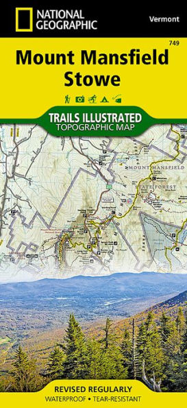
Mount Mansfield, Stowe Map
Barnes and Noble
Loading Inventory...
Mount Mansfield, Stowe Map in Chattanooga, TN
Current price: $14.95
Barnes and Noble
Mount Mansfield, Stowe Map in Chattanooga, TN
Current price: $14.95
Loading Inventory...
Size: OS
• Waterproof • Tear-Resistant • Topographic Map
Enjoy the year-round recreational opportunities in northern Vermont with National Geographic's Trails Illustrated map of Mount Mansfield and Stowe. Expertly researched and created in cooperation with the Vermont Agency of Natural Resources and others, the map delivers unparalleled detail of the area from Sandbar State Park and Malletts Bay in the northwest to the city of Barre in the southeast. Covered are tens of local and town parks; lakes, reservoirs and other waterways; state parks, forests and wildlife management areas, including the popular recreation areas Green Mountains, Camels Hump State Park and Mount Mansfield State Forest. Also covered are the cities of Burlington, Essex Junction, Montpelier, Barre and Stowe as well as a complete road network of the area.
Explore the area by traveling along mapped trails and paths, clearly labeled for hiking, biking or cross-country ski use and shown with mileage markers between intersections. The Cross Vermont, Catamount and Long Trails are all highlighted and shown with their parking areas, cabins and shelters. The Lake Champlain, Green Mountain and Mad River Scenic Byways marked as well. Other recreation points of interest noted are areas for hiking, alpine skiing, swimming, fishing, camping, canoe carry downs and picnics as well as waterfalls, covered bridges, lookout towers and interpretive trails. To aid in your navigation, the map includes contour lines, elevations, labeled peaks and summits, water features and clear color-coded boundaries between different land management agencies.
Every Trails Illustrated map is printed on "Backcountry Tough" waterproof, tear-resistant paper. A full UTM grid is printed on the map to aid with GPS navigation.
Other features found on this map include: Burlington, Colchester, Dog River, Green Mountains, Hogback Mountains, Lamoille River, Mad River, Milton, Mount Mansfield, Northfield Mountains, South Burlington, Sterling Range, Winooski River, Worcester Mountains.
Map Scale = 1:63,360
Sheet Size = 25.5" x 37.75"
Folded Size = 4.25" x 9.25"


![Appalachian Trail Map, Hanover to Mount Carlo [New Hampshire]](https://cdn.mall.adeptmind.ai/https%253A%252F%252Fgearheadoutfitters.com%252Fcdn%252Fshop%252Fproducts%252Fappalachian-trail-map-hanover-mount-carlo-TI00001511_N_20A.jpg%253Fv%253D1653095984_medium.webp)


![Mount Rogers National Recreation Area [Jefferson NF ] Map](https://cdn.mall.adeptmind.ai/https%253A%252F%252Fgearheadoutfitters.com%252Fcdn%252Fshop%252Fproducts%252FMount-Rogers-National-Recreation-Area-Jefferson-NF-CT34M_N_20A.jpg%253Fv%253D1653095956_medium.webp)