Home
Grand Canyon West [Grand Canyon National Park] Map
ROCK CREEK
![Grand Canyon West [Grand Canyon National Park] Map](https://cdn.mall.adeptmind.ai/https%253A%252F%252Fgearheadoutfitters.com%252Fcdn%252Fshop%252Fproducts%252FGrand-Canyon-West-Grand-Canyon-National-Park-TI00000263_N_20A.jpg%253Fv%253D1654202284_large.webp)
Grand Canyon West [Grand Canyon National Park] Map in Chattanooga, TN
By National Geographic
ROCK CREEK
Grand Canyon West [Grand Canyon National Park] Map in Chattanooga, TN
By National Geographic
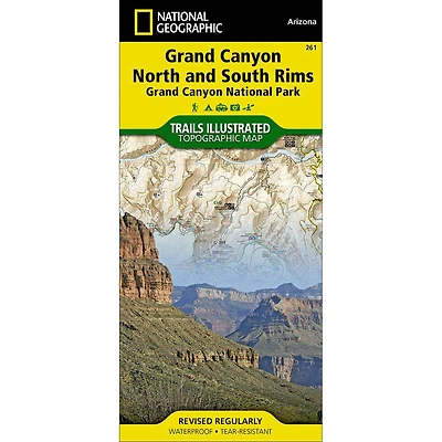
National Geographic's Trails Illustrated map of Grand Canyon West covers some of the less frequented but just as wondrous landscape of Grand Canyon National Park, from Powell Plateau to the park's western boundary. Expertly researched and created in partnership with the National Park Service, U.S. Forest Service, Bureau of Land Management and others, the map also covers the surrounding areas of Kaibab National Forest, Hualapai Havasupai Indian Reservations and Parashant National Monument. With so much of the area being backcountry, the map also includes useful backcountry information, regulations and safety tips, in addition to a backcountry use area guide, color-coded by degree of experience required.
Clearly marked trails, including unmaintained primitive trails, will guide you around the area, whether you're traveling by foot, horse, mountain bike, or motorized vehicle. The map base includes contour lines and elevations for summits, and river mileage is noted for the Colorado River. Backcountry zones within the park are marked with their boundaries and labeled with their National Park Service code. Some of the many recreation features include campgrounds and campsites, boat launches, ATV trails, scenic viewpoints, and interpretive trails.
Every Trails Illustrated map is printed on ""Backcountry Tough"" waterproof, tear-resistant paper. A full UTM grid is printed on the map to aid with GPS navigation.
- Waterproof
- Tear-Resistant
- Topographic Map
Other features found on this map include: Aubrey Cliffs, Grand Canyon, Grand Canyon National Park, Grand Wash Cliffs, Granite Gorge, Kaibab National Forest, Kanab Creek, Kanab Creek Wilderness, Kanab Plateau, Lake Mead National Recreation Area, Lower Granite Gorge, Mount Dellenbaugh, Parashant Canyon, Peach Springs Canyon, Sanup Plateau.
![Grand Canyon East [Grand Canyon National Park] Map](https://cdn.mall.adeptmind.ai/https%253A%252F%252Fgearheadoutfitters.com%252Fcdn%252Fshop%252Fproducts%252FGrand-Canyon-East-Grand-Canyon-National-Park-TI00000262_N_20A.jpg%253Fv%253D1653095970_medium.webp)